Atal Rohtang Tunnel : The World’s Longest High – Altitude Tunnel

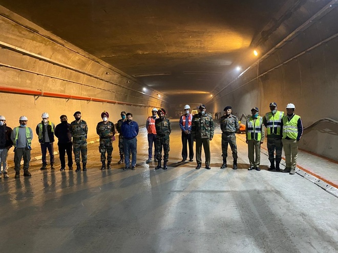
The view from inside the world’s longest high-altitude road tunnel built under the Rohtang Pass
The requirement for an ‘all-weather’ route from Leh to Manali had been projected aeon ago but the Government kept sleeping. It became very important after the 1999 Kargil war. The plan to build a 4.15 km tunnel reaching the Nimu-Padam-Darcha green zone was re made. The Geological Survey of India gave the green signal for the tunnel in 2,000 with a warning that the rocks on the south portal were unstable. In 2002, former prime minister Atal Bihari Vajpayee gave orders to build the tunnel. The BRO, along with some private firms, started work on the project, with construction officially beginning on March 4, 2010.
The tunnel’s south portal area is 25 km from Manali, while the north portal is located near the Teling village in Lahaul at an altitude of 3,071 meters.
The tunnel project faced major challenges due to excessive snowfall. When the work picked up pace near the south portal, water from the Seri drain and the mountain silt seemed relentless, severely complicating work. Then technical arrangements were made to control silting by creating a separate route for the drainage water. About Rs 4,000 crore have been spent to build the tunnel which has extensive air management and also fire-fighting equipment fitted every 50 metres.
After a struggle spanning nearly a decade, an amazing example of tunnel engineering is now ready on the Manali-Leh highway. Important from a strategic and security point of view, the Atal Rohtang Tunnel carved out under the Rohtang Pass is the longest high-altitude road tunnel in the world. Scheduled to be inaugurated by Prime Minister Narendra Modi in late September, the tunnel will ensure uninterrupted, round-the-year traffic between Manali and Leh. Himachal’s tribal district Lahaul-Spiti, too, will be connected with other parts of the state even during winters. The tunnel is along one of only two routes into Ladakh and will become key to resupplying the military garrison there. The other route into Ladakh is via the Zojila Pass which connects the Kashmir Valley with Drass.
As you enter the 10-metre wide, horse shoe shaped tunnel, located at 10,000 feet, you are hit by a strong gust of wind sweeping in from the treeless, snow clad mountains. There is no human habitation for miles around. It would normally take around five hours to cross the Rohtang Pass—a route marked by heavy vehicular traffic, tourists stopping for a glimpse of the snow, and military convoys headed north. The tunnel changes all that. It zips you under the pass in just 10 minutes. It shrinks the Manali-Leh road by 46 km.
Making this 8.8 km-long tunnel was no easy task. This part of the country remains cut-off for about six months in a year because of heavy snow cover. The Atal Rohtang Tunnel will prove very important for smooth movement of goods to and from Lahaul. Four more tunnels across passes on the way to Leh have been proposed. Outlines for one such tunnel, passing through the Baralacha Pass, have been drawn and forwarded to the Centre for approval. The other two tunnels will be built at Lachung La and Tang Langla, which will be connected directly to Leh. Reflecting on the importance of the tunnel, Major General D.V.S. Rana (retd) says, “All weather roads are very important for the military.”
Named after former Prime Minister Atal Bihari Vajpayee, the Atal Rohtang tunnel connects Manali in Kullu district and Himachal Pradesh’s Lahaul-Spiti district. It is 8,802-metres long and about 3,000 metres above sea level. The single tube bi-lane tunnel, 5.5 metres high, was bored through solid rock nearly two kilometres under the Rohtang Pass. The makers used a drill and blast technique for excavation, coupled with the New Austrian Tunnelling Method for construction.
Another parallel tunnel of 3.3×2.2 metres, an emergency passage of sorts, has been constructed under the Atal Rohtang tunnel with staircases at every 500 metres connecting it to the main tunnel. Three thousand cars and 1,500 trucks can pass through the Atal Tunnel at 80 km per hour.
People of both Buddhist and Hindu religions live in Lahaul. Since it lies to the south of Ladakh, it has been given the name Lho-yul, meaning the southern province in Tibetan. People also consider it as a country of passes. To Lahaul’s east is the Kunjam Pass, while Rohtang lies in the southwest, Baralacha in the north and the Saach Pass in the south, which connect Lahaul to Ladakh, Spiti, Kullu and Chamba.
In the month of June-July, people used to carry their goods on cattle and travel through these passes to the other main parts of the country. The Atal Tunnel ripping through the Rohtang Pass is significant for the people in the area who had, till 1964, not even seen a car in the region and for whom, convenient transportation was a distant dream.


